Monday, May 25, 2015

Homeward Bound

Travel Day

  • Fernie, BC to Calgary, AB via BC 3, AB 3, AB 22 and AB 22X
Sparwood is about a half hour past Fernie, BC on Highway 3, aka The Crow's Nest Highway. The "big truck" is in Sparwood. Whenever I go by, I take a picture. I have lots of pictures of the "big truck". Here is another one.

The big truck is a coal hauler from the Elkview Coal Mine, the second largest mine in BC. This gentle slope is not some soft mountain side, but the outer berm of a massive open pit operations.

Home, sort of. Almost home.

A stop at the Frank Slide is always in order when I drive through the Crow's Nest Pass. I always reminds me of the Hope Slide, which happened when I was 10 years old. I remember the temporary road through that slide. And it looks a lot like the Frank Slide.

This is the slide rubble field. That hillside up there is what fell down into the valley.

Just like the Hope Slide, the road goes right through the Frank Slide. Even after 100 years there is nothing growing in most of the rubble field.

My last shot for the day. Rubble is not all small. After taking this shot I got the call about my apartment not being ready for three more weeks. I got distracted and didn't take any more pictures. Sorry.

Sunday, May 24, 2015

I'm Back In Canada, Eh.

Travel Day

  • Post Falls, ID to Coeur d'Alene, ID via I-90
  • Coeur d'Alene, ID to Fernie, BC via US 95, BC 95 and BC 3
One more look out my balcony door before heading on the road again.

I turned left. I did not want to go to Moscow, nor did I want to "Float The Lazy River". I did, however, want to go to Canada with a stop in Sandpoint.

Sandpoint is a resort town on Lake Pend Oreille in northern Idaho. It is a beautiful lake with wonderful beaches and boating.

It was interesting to see all the sailboats here at the lake. It's a big lake, so I guess sailing is a thing here.

Approaching the border; still some distance away but getting closer.

This is the view from where I took the previous picture. Up there in the valley of the Kootenay River is Creston, BC. At this point the Kootenay River is headed north, up into Kootenay Lake. From there it flows out of the lake and into the Columbia River.

The Eastport, ID / Kingsgate, BC border crossing. The lineup was almost an hour for some reason. Oh well, border crossings can be like that.

Cranbook is the first major center east of the Kingsgate crossing. I took the picture but did not stay.

Instead I drove an hour further down the Crow's Nest Highway, aka BC 3, to Fernie. Sorry about the picture. I just grabbed the camera and snapped without looking.

The town of Fernie is an old mining town. Most of the original housing was built by mining companies for mine workers. Many of the original homes are essentially unchanged, but lovingly cared for.

Downtown Fernie has that funky old mining town look to it, with the square block utilitarian buildings. The city has done a lot to cheer it up, though.

There is a lively sidewalk cafe and pub business in town. Most places have something like this outside.

Even the Fernie City Hall is rather interesting looking. It is a "hip roofed barn" styled building, only done in stone. 

Just a reminder, I am back in the Canadian Rockies.

Saturday, May 23, 2015

Coeur D'Alene Rest Day

Travel Day

  • No Travel.  I took a rest day in Coeur D'Alene with a short exploration of the area.
This is my first picture of the day. For a while I thought this was as far as I might go, taking the day to sit and watch the river, the boats, the trees... a day to relax.

Eventually I got out, into my truck and into Coeur D'Alene. Sorry about the picture quality. It was a quick snap while I was stopped at the light.

Coeur D'Alene is all about the lake. Sure there are a couple of colleges and a university; sure there is a lumber industry; sure there are lots of other things. But it really is all about the lake.

Downtown Coeur D'Alene; tree lined streets, restaurants, bars and cafes on the street. It is a lovely town.

But it really is all about the lake. The temperature was 84° F today. People were out loving the sunshine.

The big deal is to take your boat from down the river, roar up to the lake, and drift downriver again. You can stop along the way at any number of swimming holes.

And if you don't have a boat, you can always suntan on the dock.

Just a reminder. There is more here than the lake. Forestry is big business here in northern Idaho.

Do you think Nenshi might let me open one of these in Calgary? After all, what could possibly go wrong with drive thru liquor?

My last picture of the day; similar to the first. I like it here.

Friday, May 22, 2015

Ontario, OR to Couer D'Alene, ID... And Then A Bit Further

Travel Day

  • Ontario, OR to Couer D'Alene, ID via US 95
  • Couer D'Alene, ID to Post Falls, ID via I-90

I started out this morning in Ontario, OR, which is right next to the Snake River, the dividing line between Idaho and Oregon in this region. My first step was to cross the Snake River.

And that means I was headed into Idaho.

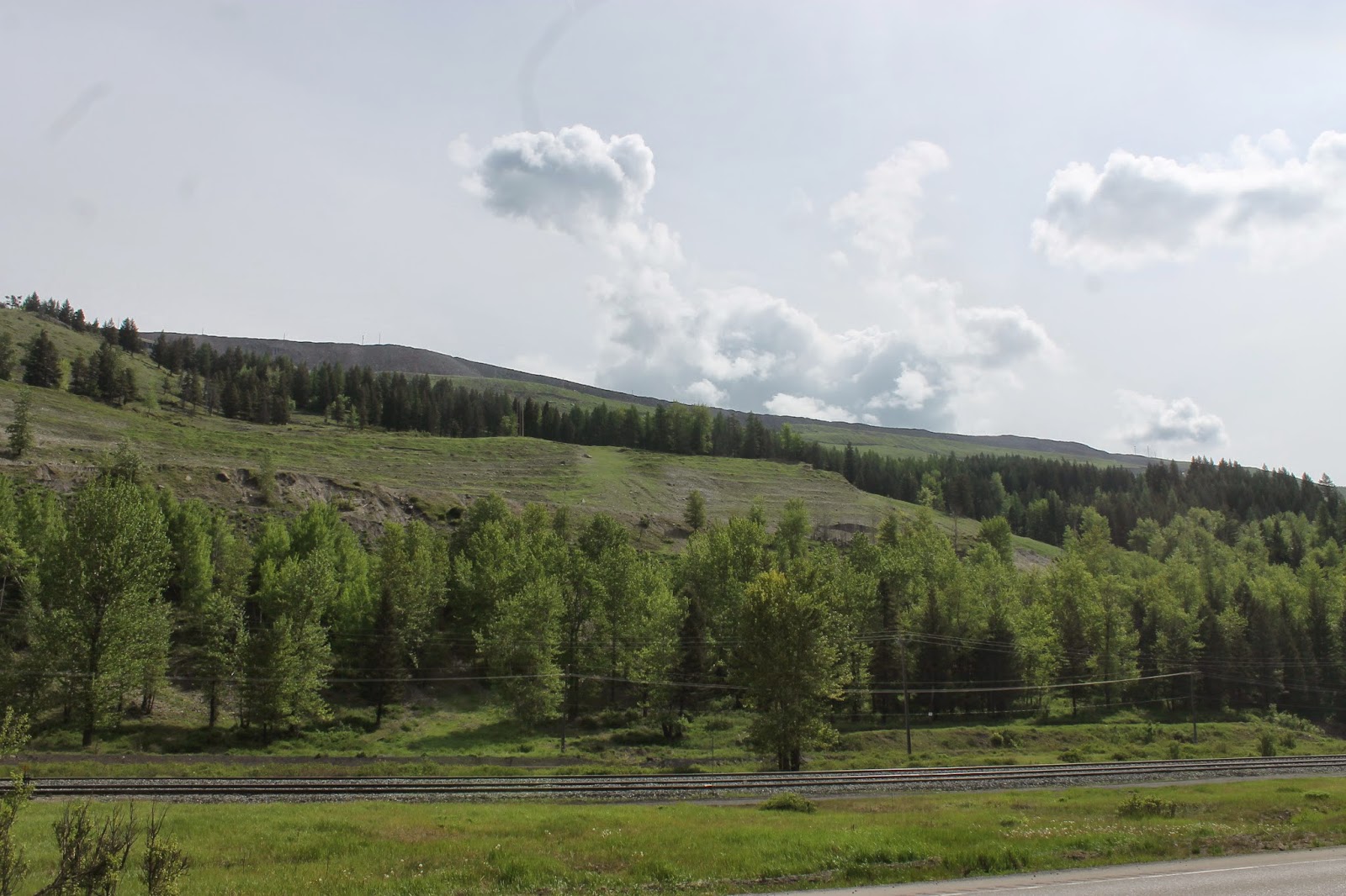
I pick up US 95 as it heads north, up into the hills and then down onto the vast plateaus below. There is a lot of agriculture here, much more than I expected. I was expecting more forests and mountains.

There are forests here, as the highway rises up the various hills and down river canyons to the next plateau. The forests here are typical of interior woodlands, with widely space pines and other evergreens, along with a grassy forest floor.

This is the Little Salmon River, which eventually becomes the Salmon River. I took this shot high in the Salmon River Canyon. There are a million rapids and rocks, thousands of waterfalls, eventually taking this water to the Snake, then the Columbia, then the Pacific Ocean.

The Salmon River is famous for, well, salmon fishing. These folks are all camped on one side of the road so they can go fishing on the other.

The Salmon River as it heads through the lower Salmon River Canyon. It's also popular for boating and white water rafting.

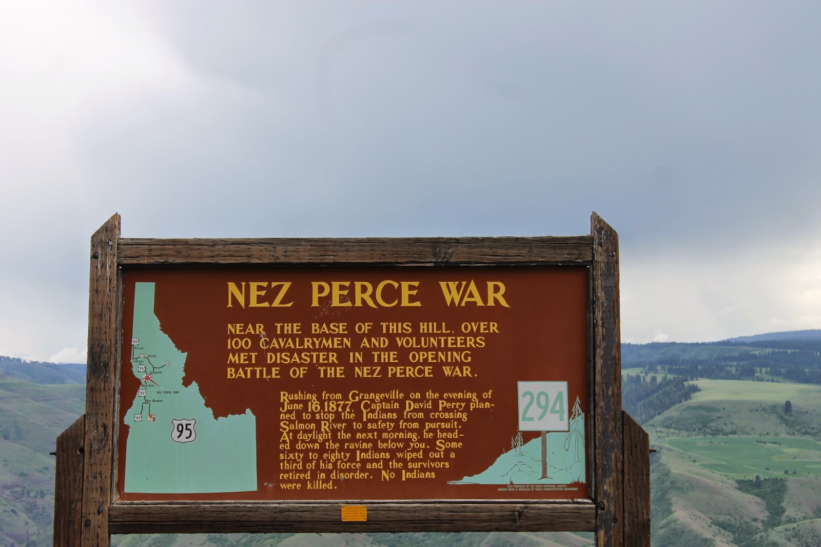
This is a look down White Bird Hill, a place of some significance to the Nez Perce Indians who populated this region before the white man took the land from them.

These historical markers are all along US 95. This one explains the importance of White Bird Hill.

This is a look up the grade of White Bird Hill. There was an older road before this, with all kinds of turns and switchbacks. Now the new highway makes the hill steeper, but faster.

If you are interested in this stuff... (Mike George, read here.)

On the other side of White Bird Hill you come down onto another wide open prairie. This happens a lot along US 95.

Another Historical Marker, if you can read it.

On the other side of Camas Prairie, you go through another canyon. If you look very closely in the center of the picture you will see a trestle bridge.

Here is the what-for on that bridge.

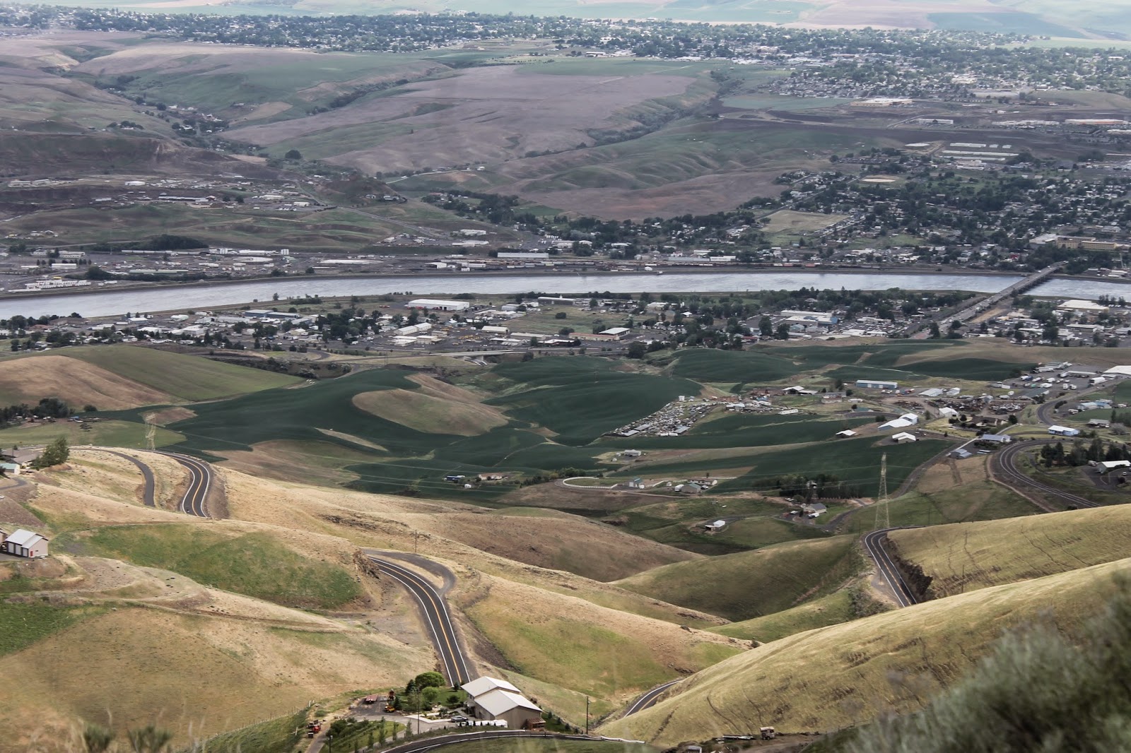
At Lewiston, ID, the Snake River takes a sharp left turn. That turn is where the Clearwater joins the Snake. One one side of the river is Lewiston, ID. On the other side of the river is Clarkston, WA.

Here is a bit of history about the rivers, if you are interested, and can read the fine print.

That road snaking down the hillside below is the old highway, built when the grade had to early automobiles.

One again, the Oregon History Association provides some interesting details about the road.

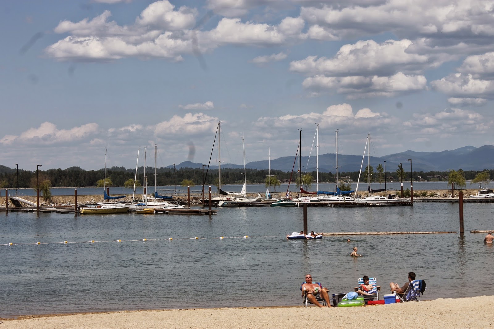
Cougar Bay on Couer D'Alene Lake. This is more what I expected of Idaho; trees, mountains, lakes.

I have almost arrived. While my general target was Couer D'Alene, I am staying in Post Falls at the Red Lion on the Spokane River.

In order to get there, I had to cross said river.

This is the evening view from the patio of my room. That is the Spokane River . There are boats here. I like that.