Tuesday, June 30, 2015

Up The Dempster Highway

Travel Day
  • Dawon City, YT to Eagle Plains, YT via The Klondike Highway and The Dempster Highway
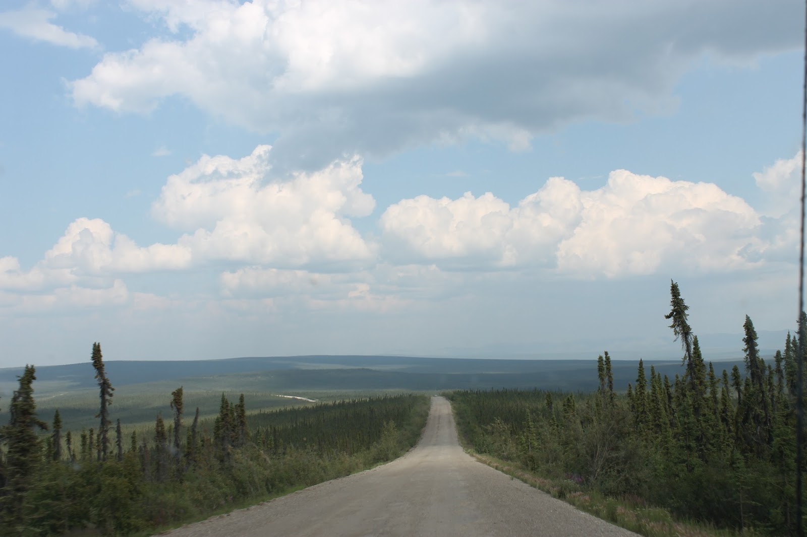
We headed up the Dempster Highway today, the only road in Canada to cross the Arctic Circle. It's 775 km of dirt highway, well packed but dusty when dry and muddy when wet.

In other words, "Abandon hope all ye who enter here."

First we had to cross the Klondike River, just as the highway starts. Fortunately there is a bridge.

The road ends and the gravel begins fairly quickly after crossing the bridge.

This is the Tombstone Interpretive Center in Tombstone Territorial Park. This centre explains the northern environment to visitors. It'a about 74 km up the highway.

There seems to be no end of inuksuk up here.

We stopped at Two Moose Lake, but we saw no moose whatsoever.

The Ogilvie is one of the main rivers up alongside the Dempster. The highway follows it for some time.

You can see the water from Red Creek as it mixes with the clear water of Ogilvie River.

Ogilivie Ridge overlooks the Peel River, and a ton of territory.

Just a part of the massive countryside up here, as seen from Ogilvie Ridge.

The highway generally follows the high ridges along the mountains, giving some fabulous views. You can see forever up here.

We ended the day at the Eagle Plains Hotel in Eagle Plains, YT.

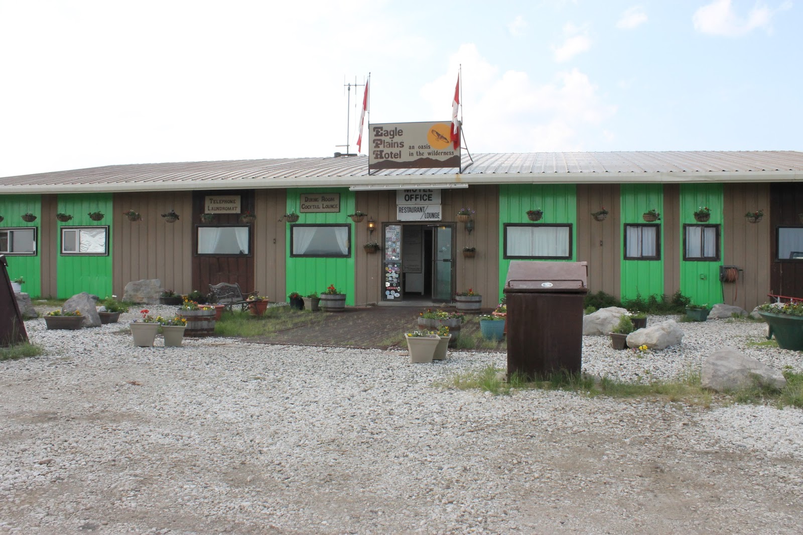
It's actually a fairly large installation with the hotel, restaurant, lounge, and gift shop. There is also a gas station here.

At the back of the hotel is a viewing stand to look down into the valley below. Apparently you can see moose and bear here on occasion.

Monday, June 29, 2015

Dawson City, YT

Travel Day

  • No Travel. Katherine explored Dawson and then we went to the Bonanza Creek Gold site.
Katherine walked around Dawson City and took some pictures of some of the buildings. The newer ones are mostly like this, brightly painted with false fronts and either tin or wood siding on the sides and rear.

This is one of the two grocery stores in town.

There are a lot of really old buildings in town as well, some maintained, some not.

As she arrived at the river walk, she found the SS Keno, an old paddle wheeler now kept up on blocks by the river.

If you want to go on a paddle wheel river tour, there is always this little cutie.

Looking across the Yukon River towards West Dawson. There is a ferry across which runs all day, on demand.

Katherine just liked this sign. It is the local gas station.

This is the Dawson City Museum. It looks very cool but we didn't manage to get inside.


After she came back to the hotel, we went up the Bonanza Creek Road to the site of the original Klondike gold discovery. Here is the famous Dredge #4, one of the largest self-floating gold dredges ever used in Canada. It is just downstream from the original strike.

Yep, that's me. Yep, that's my truck. Yep, I was there.

 After checking out the dredge, we went up to the Discovery Claim on Bonanza Creek, the source of all the excitement between 1898 and 1901 here in the Klondike.

You can still pan for gold in Bonanza Creek, and some people still find it now and again.

On the other hand, this is the industrial method of placer mining, where you dig up massive amounts of earth, run it through a sluice, and leave your tailings where they land.

In fact when the claim runs dry, most miners left a lot of equipment just sitting in the bush.

The miners' cabins didn't do so well either.

The rock pile in front is a tailings pile. The landscape in back is scarred from industrial strength gold placer mining. It's still out here.


Sunday, June 28, 2015

End Of The (Paved) Road

Travel Day

  • Whitehorse, YT to Dawson City, YT via YT 2 (The Klondike Highway)
Heading out of Whitehorse, we took a picture behind us. Whitehorse is in the valley, or canyon, of the Yukon River. The Alaska Highway and the Klondike Highway are up on the ridge.

Heading out of Whitehorse, there is more wilderness. It goes on and on.

The first crossing of the Yukon River is at Carmacks. They have this really cool sign for the village.

And of course, you cross the Yukon River.

A look at the Yukon River from the bridge.

This is the Five Finger Rapids on the Yukon River. Yes, the highway stays near the Yukon River for most of its run.

On the other hand, you also cross the Pelly River just before it joins the Yukon River. This is Pelly Crossing.

Next is Stewart Crossing, which crosses the Stewart River, just before it joins....

As we headed into Dawson City, the highway was blocked by a fairly serious accident. Fortunately we were able to take a side road through the bush.

The first "Welcome" sign for Dawson City.

This is the second Dawson City sign, so much more fun than the first one.

In order to get to the real "Dawson City", you have to cross the Klondike River. All along the edge of the river there are gravel piles from placer mining in the Klondike River.

Finally, the real Dawson City marker.

A western saloon housing a Chinese restaurant. Every town up here has its Chinese Buffet.

This is a look at our hotel. The Westmark Hotel actually has four different buildings, all fixed to maintain the character of the town.
There were a bunch of these old cars on parade through the town. They must have made the run up from Whitehorse. These are brave folks up here.

Looking across the street from the main hotel building, we are in the yellow section. Remember, these are all false fronts designed to maintain the character of the town.

Saturday, June 27, 2015

A Day In Whitehorse, YT

Travel Day
  • No Travel. We spent the day in Whiteshorse, YT, exploring.
We stepped out of our hotel this morning to find ourselves in the midst of the Gay Pride Day parade.

We were happy to see that the RCMP were able to put one of their patrol cars in the parade.

We wandered down towards the historic area and found ourselves at the Dawson-Ashcroft Telegraph Station.

For those of you who prefer to read.

The Telegraph Station is a part of the MacBride Museum of the Yukon here in Whitehorse. This place is pretty cool, in spite of the name. Unfortunately photography is prohibited inside the museum, so the oldest thing you get to see is me.

This cool totem pole is on the river pathway. The totem pole is the thing behind Katherine.

We walked along the river bank, under the bridge to the north side of the river. This is the Yukon River.

And this is another view of the SS Klondike, this time showing the undercarriage and the paddle wheel.

Katherine got to the upper deck on the paddle wheeler. She was naturally drawn to the kitchen. What can I say?

This is the boiler, the fire end of the boiler. This is where the stokers worked. I post this picture in honour of my Dad, a stoker in the Canadian Navy. However I am pretty sure he did not have to throw logs below a boiler.

Yep, that's me. Yep, that's my wheelchair. Yep, I was there.

The Yukon parliament building and administrative headquarters.

An interesting shot of downtown Whitehorse.

Whitehorse may make this claim, but really Robert W. Service was a Dawson City man.

After wandering downtown for a while, we went up the hill to the airport area This is one of the water bombers that helps with the fire situation up here, something we are expecting to have to deal with tomorrow.


Up on the highway, above town, near the airport is the Beringia Interpretive Center. Part of the display is this statue of a wooly mammoth, a species that live here about 10.000 years ago.

This is one of the original CP Air DC3's which served Whitehorse. This plane is displayed outside the Yukon Transportation Museum, up on the upper highway. 

This fascinating piece of equipment is also on display outside the Transportation Museum. Notice the US Army markings. This machine was used to build the Alaska Highway.

This barge is also on display. I don't know what it is all about, but I thought it was cool, as did Katherine.

And then there was this, the little engine that could.

We went back to the hotel where Katherine said I could have two beers. I did.

She had one too, and we had a wonderful end to our day.